TERENO Newsletter 2/2024
nl_2024_3
Banner-Ozcar-Tereno-Conference_2025.png
nl_2024_2
elter.png

The Eifel/Lower Rhine Valley Observatory is operated by Forschungszentrum Jülich since 2008. The central monitoring site of the Eifel/Lower Rhine Valley Observatory is the catchment area of the River Rur because it covers the distinct gradients in landscape features in this region. It comprises a total area of 2354 km² and is situated mostly in North Rhine-Westphalia (Germany). From the northern to the southern part of the observatory, altitude increases from 64 to 630 m, mean annual air temperature decreases from 10 to 7°C and mean annual precipitation increases from 650 to 1300 mm. Land use is highly differentiated: The lowland region in the northern part is characterised by urbanisation and intensive agriculture whereas the low mountain range in the southern part is sparsely populated and includes several drinking water reservoirs. Furthermore, the Eifel National Park is situated in the southern part of the Rur catchment serving as a reference site.
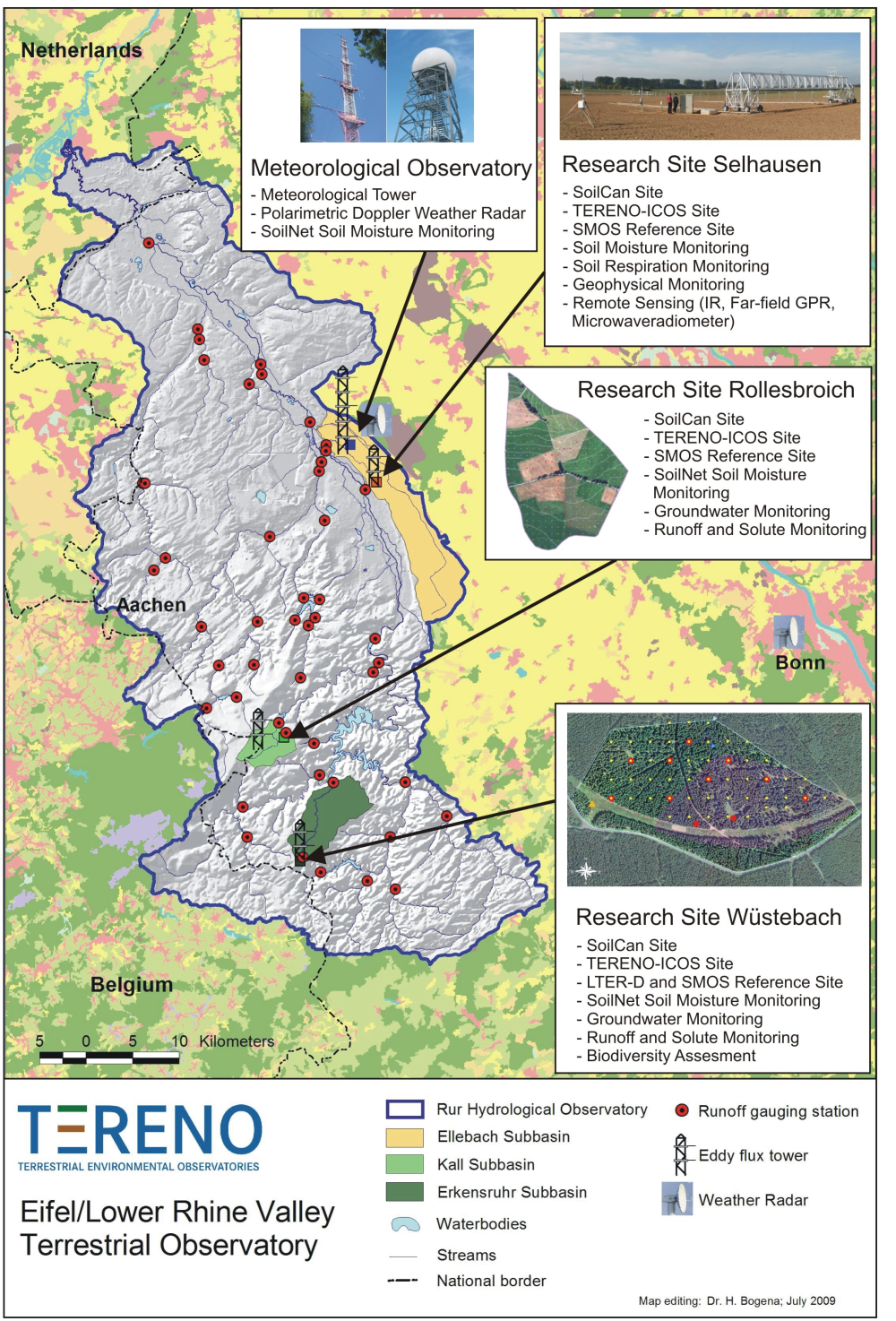

The general observation strategy follows a nested multiscale approach: More detailed measurements and characterisation of smaller, focal catchments are embedded within progressively larger catchments, allowing the critical evaluation and development of scaling strategies. Intensive test sites placed along a transect across the Rur catchments investigate the effects of climate change and anthropogenic land use on water (quality of runoff, precipitation and groundwater), energy (sensible heat, evapotranspiration, CO2 and momentum) and soil parameters (soil moisture, water content, density, texture, etc.). 

The Rur hydrological observatory is part of the European Network of Hydrological Observatories (ENOHA, www.enoha.eu) initiative. In addition, data acquired in the Rur hydrological observatory is feeded it into other databases, such as the International Soil Moisture Network (ISMN) and the Integrated Carbon Observation System (ICOS) to further ease data usage.


Reference: 

Bogena, H.R., C. Montzka, J.A. Huisman, A. Graf, M. Schmidt, M. Stockinger, C. von Hebel, H.J. Hendricks-Franssen, J. van der Kruk, W. Tappe, A. Lücke, R. Baatz, R. Bol, J. Groh, T. Pütz, J. Jakobi, R. Kunkel, J. Sorg and H. Vereecken (2018): The TERENO-Rur Hydrological Observatory: A Multiscale Multi-compartment Research Platform for the Advancement of Hydrological Science. Vadose Zone J. 17(1): 1-22, doi:10.2136/vzj2018.03.0055.


Presentations

Agenda by Kaiser.pdf


Meeting welcome by Bens.pdf


GHG exchange grassland ecosystems by Kiese.pdf


Hydrology of a groundwater-dominated lake system by Blume.pdf


Interdisciplinary research in the Schäfertal catchment by Wollschlaeger.pdf


Long-term experiment Wuestebach by Bol.pdf


Modelling tree sap flow by Priesack.pdf


SoilCan by Puetz.pdf


TERENO data management by Kunkel.pdf


TERENO overview by Vereecken.pdf


TERENO-MED by Friesen.pdf


Presentations

TERENO Data management

TERENO Presentation Vereecken

Validation of distributed soil moisture by Jagdhuber

TERENO MED

Tree growth dynamics in relation to changing climate and hydrology... by Heinrich et al.

Coupled runoff model of the Ammer catchment by Smiatek

Analysis of runoff components and residence times by Stockinger

TERENO Pesticide Initiative by M. Bekethov et al.


Poster

Cosmic Ray Sensor by Roland Baatz


Isotope Patterns for Catchment Study by Christine Müller
Müller, C., R. Merz, R. Krieg, and K. Knöller. Assessment of Large Scale Hydrological and Hydrochemical Processes by Means of Regional Isotope Patterns in the TERENO Bode Catchment


DEMMIN in TERENO NE: The year 2012… by Blasch et al.


Confocal laser scanning microscopy (CLSM)… by Wei Liang et al.


Dynamic growth responses of oak and beech… by Pohlmann et al.


Agenda

TERENO AB Meeting 2011 Agenda.doc


Talks

Talk H. Vereecken


Talk D. Borchardt


Talk I. Kühn


Talk K. Rinke


Talk A. Brauer


Talk M. Masbou


Talk M. Dannenmann


Talk U. Wollschläger


Talk R. Kunkel


Talk A. Reigber


Talks

Talk H. Vereecken


Talks

Heye Bogena Eifel Lower Rhine Valley Observatory


Steffen Zacharias Harz Central German Lowland Observatory


HaPe Schmid Bavarian Prealpin Observatory


Achim Brauer Northeastern Lowland Observatory


Andreas Reigber Environmental Sensing Status


Heye Bogena Data Management


Talks

Stefan Klotz Climate-change


Heye Bogena NOHA


Harry Vereecken TERENO


Cornelia Ohl TERENO-Socio


HaPe Schmid Atmosphere - Land Surface Interactions


Eckart Priesack: Climate change and sustainable use of soils


Irena Hajnsek Remote sensing


Within the regions are instrumentations of "Global Change Stations" (catchment areas) as part of the TERENO observatories and the enhancement of existing research stations (e.g. Höglwald, Scheyern) designated. Furthermore mobile measurement platforms for monitoring dynamic processes at the local scale up to the determination of spatial pattern at the regional scale will be applied:


  • Measuring systems for the determination of regional precipitation fields at temporal and spatial scales (e.g. using additional weather radars or densification of precipitation gauging networks)
  • Micrometeorological eddy-covariance systems and scintillometer for the determination of atmospheric parameter and fluxes of water vapour, energy and trace gases at different scales
  • Sensor networks for determination of environmental parameter at a high spatial and temporal resolution (e.g. patterns of soil temperature and moisture dynamics)
    Monitoring systems for the quantification of water and solute discharge in surface waters and groundwater
  • The remote sensing part of TERENO include:
    • Operation and development of ground-based and airborne measurement platforms (e.g. towers, ultra-light aircrafts)
    • Acquisition of geophysical and spectral sensors (e.g. hyperspectral systems and infrared cameras, microwave radiometer, SAR, LIDAR, air-chemistry instruments)


Further infrastructure measures include high capacitive data processing and communication systems to guarantee a fast availability and long-term protection of the gather environmental data sets. Existing measuring platforms and sensors within the Helmholtz-Gemeinschaft will be as far as possible used, adapted with regard to a flexible application for longer periods and demand-oriented extended and further developed, respectively. This instrument pool represents the core of the planned terrestrial observatories, which will be extended according to the specific requirements of the research centres.

The interdisciplinary and multi-scale character of the planned TERENO activities demands a comprehensive and coordinated implementation process. Therefore an iterative procedure is intended, in which the first focus will be the monitoring of fluxes of water and matter representing basic indicators of changes in ecosystem functions since they are directly influenced by Global Change. Additionally, specific research complements will be integrated according to the core competences of the particular research centre, which can be extended in further project phases by including additional cooperation partners outside of the HGF (e.g. universities).

The interdisciplinary investigation of Global Change effects demands an adequate number of research sites with different characteristics and a sufficient replication in regions, which are already affected by Global Change or will sensitively react in foreseeable time, or in which extreme landscape changes take place. Therefore, in the framework of TERENO regional "terrestrial observatories" will be set up in selected and for Germany representative regions by integrating existing research stations and activities. These observatories will be equipped with a combination of in-situ measuring instruments and ground-based, airborne and satellite-borne remote sensing techniques.


The terrestrial observatories have to be operated on a long-term basis (at least for a decade), in order to facilitate the determination and quantification of environmental changes. Through cooperations with other networks the national observatory network will continuously extended in the following on a European and global level. For the first phase three regions in Germany have been identified:

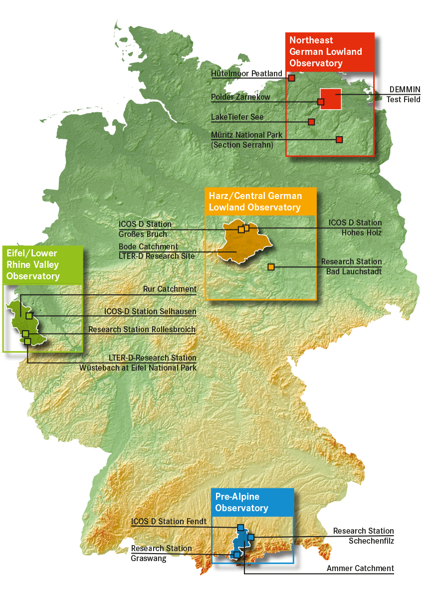
  • Site A: The Eifel/Lower Rhine Valley Observatory (coordination: FZJ)
  • Site B: The Harz/Central German Lowland Observatory (coordination: UFZ)
  • Site C: The Bavarian Alps/pre-Alps Observatory (coordination: KIT and HMGU)
  • Site D: The German Lowland Observatory (coordination: GFZ)


Terrestrial Environmental Observatories


Northeast German Lowland Observatory

Coordination: GFZ


Harz / Central German Lowland Observatory

Coordination: UFZ


Eifel / Lower Rhine Valley Observatory

Coordination: FZJ


Pre-Alpine Observatory

Coordination: KIT

Northeast Central Lowerrhine Pre-alpine


The main goal of the infrastructure measure TERENO will be to create observation platforms on the basis of an interdisciplinary and long-term aimed research program with a close cooperation between several facilities of the Helmholtz-Gemeinschaft for the investigation of consequences of Global Change for terrestrial ecosystems and the socioeconomic implications. TERENO will provide long-term statistical series of system variables for the analysis and prognosis of Global Change consequences using integrated model systems, which will be used to derive efficient prevention, mitigation and adaptation strategies.

Important system variables are amongst others fluxes of water, matter and energy within the continuum of the groundwater-soil-vegetation-atmosphere system, long-term changes of the composition and functioning of micro-organisms, plants and fauna as well as socioeconomical conditions, which have to be determined with an adequate temporal and spatial resolution in dependence of the dynamics of the involved processes.


The complex interrelations and feedbacks of the different parts of the terrestrial systems require an interdisciplinary approach. In this context important questions are:

  • Which consequences have the expected climate changes on the terrestrial compartments (groundwater, soils, vegetation, surface waters)?
  • In which way will the feedbacks of the exchange processes of terrestrial systems (e.g. feedbacks between land surface and atmosphere) affect the terrestrial fluxes of water and matter?
  • Which direct influences have soil and landuse changes (e.g. due to EU Cross Compliance Directive, promotion of energy crops) on water balance, soil fertility, biodiversity and regional climate?
  • What are the consequences of large anthropogenic interferences (e.g. open mining, deforestation) on terrestrial systems?


The homogeneous long-term data sets provided by TERENO will significantly foster the validation, advancement and integration of terrestrial models (e.g. groundwater and soil water balance models, regional climate and weather prognostic models, air quality models, runoff and forest/agronomic models as well as diversity and socioeconomical models). Integrated model systems will significantly support the management of agronomic and forest ecosystems (e.g. optimisation of irrigation systems as well as development of warning systems for extreme weather occurrences and flooding, integrated control systems of water management constructions, and monitoring systems for air, groundwater and surface water quality).