TERENO Newsletter 2/2024
nl_2024_3
Banner-Ozcar-Tereno-Conference_2025.png
nl_2024_2
elter.png

The CT Atmosphere concentrates on the regional effects of Global Change on the atmosphere and the atmosphere-surface interaction. The expected climate-induced changes and land-cover changes at the TERENO observatories (forest transformation, urban sprawl, energy plants, natural species composition change) will lead to a change in several climate parameters (amount and temporal and spatial structure of precipitation, temperature, moisture, and wind) as well as in the exchange fluxes between the atmosphere and the underlying surface (turbulent fluxes of CO2, H2O, further trace gases, energy, radiation, momentum). A deepened understanding of these air/surface exchange processes and their dependence on regional climate change is necessary for improving simulation models to achieve authoritative forecasts on atmosphere-surface interaction.


Using unified measurement installations and protocols in all TERENO catchment areas, the following tasks are planned in close cooperation with the other CTs:

  • Regional precipitation measurements to document the long-term change in large-scale and convective precipitation. These measurements could be compared to climate predictions and results, e.g. from the recently performed COPS experiment. Data will be exchanged with the CT Hydrosphere.
  • Feedbacks of changes in vegetation on the atmosphere-surface exchange. Here a clear interaction to the CT Biosphere will be necessary. The focus will be on CO2- and H2O-fluxes.
  • Investigation of different procedures for a regionalization of the results. This includes two subtasks:
    • Upscaling of local in-situ measurements in the TERENO observatories to the catchment and regional scale,
    • Investigation of the influence of the local vertical structure of the atmospheric boundary layer on local measurements (i.e. to separate between local and regional effects on point measurements).


Members

  • Alexander Graf (FZJ)
  • Marius Schmidt (FZJ)
  • Anke Hildebrandt (UFZ)
  • Cornelia Rebmann (UFZ)
  • Rainer Steinbrecher (KIT)
  • Matthias Mauder (KIT)
  • Stefan Emeis (KIT)
  • Clemens Drüe (Universität Trier)

The main focus of the CT Environmental Sensing will be the estimation of bio-/geo-physical parameters using different sensing instruments. Different research institutions will participate with their sensing instruments and platforms to the collection of parameter derivations.


The CT Environmental Sensing is defined by the operation of different instruments on different platforms and by the derivation of bio-/geo-physical environmental parameter from these. This information is used as the input for higher order models or land process models in order to reduce their statistical variability and improve their accuracy and reliability. The sensing of the region of interest can be done on a local, regional and/or global scale. Depending on the required information content, the sensing can be done in high spatial resolution (1-10m), on a large scale coverage (swath 15-100km), frequently (daily to monthly), at any time of the day (e.g. radar) and weather independent (e.g. radar). Since ground based measurements are limited in plot size measurable per unit of time, the integration of methods up to the catchment scale within a hierarchical approach is favourable:


 This will include the integration of surface based measurements with geophysical platforms, handheld spectroscopy and sampling at points as well as the up-scaling to spectroscopic measurements and also airborne and spaceborne measurements. In order to reach the research hypotheses the CT Environmental Sensing will follow the approach of the following tasks:

  • Collection and coordination of requirements from the different CT's (CT Environmental Sensing is acting as an interface between the other CT's)
  • Coordination of flights and instruments over regions of interest
  • Coordination of common instrument operation over regions of interest
  • Intercomparison of field instruments
  • Coordination of airborne/spaceborne data acquisition with ground measurements
  • Reporting on data processing status and data quality
  • Exchange of inversion procedures for the environmental parameters
  • Synergies between different sensors
  • Collection, coordination, archiving of different types of data


In order to make measurements from different instruments comparable to each others and to ensure a defined level of quality, cross-calibration of measurement equipment is necessary. For optical measurement systems used for environmental remote sensing DLR Oberpfaffenhofen operates an optical laboratory (CHB - Calibration Home Base) for the calibration of hyperspectral airborne sensors and field spectrometers. This facility will be used by the TERENO partners to characterize the radiometric and spectral properties of their radiometers, IR-cameras, optical cameras, and imaging spectrometers in the spectral range from 380-2500 nm. Equipment is available to investigate irregular instrument properties, e.g. spectral filters for stray light measurements. Furthermore, the partners will bring their own calibration equipment (e.g. radiance standards, reflectance panels for lab and field use) to the CHB for calibration. In addition, optical components from their labs (e.g. spectral transmission of filters) can be characterized spectrally. It is intended to perform annual campaigns in the CHB to characterise and intercompare the instruments of the TERENO partners in the CHB for the TERENO partners. DLR will also purchase and maintain a calibrated field spectrometer for in-situ spectral measurements of radiance, irradiance and reflectance. It is available for the TERENO team to perform validation measurements at the test sites during airborne campaigns. Organisation of calibration campaigns as well as coordination of resources will be covered by the CT Environmental Sensing.


Members

  • Irena Hajnsek (DLR)
  • Erik Borg (DLR)
  • Carsten Montzka (FZJ)
  • Wolfgang Junkermann (KIT)
  • Sibylle Itzerott (GFZ)
  • Angela Lausch (UFZ)
  • Andreas Reigber (DLR)

The CT Data Management will facilitate the acquisition, provision, integration, management and exchange of heterogeneous digital resources within a scientific and non-scientific multiuser (distributed) environment. The CT Data Management also prepares agreements for data storage and data exchange standards in the different observatories. Important is the development of a joint concept of the involved centres for data management in order to guarantee data access compatibility for the different TERENO sites. The FZJ will coordinate the overall data management for the TERENO project.


A data policy statement, required for data processing and exchange in this project, will be developed in a participatory approach with all institutional project partners. A main aspect of data policy is the definition of data ownership (intellectual property rights) and data access rights concerning funding organization directives differentiated by types of digital resources, their process status, the data creator and the data source.


A data management plan will be developed that considers a number of commitments and agreements, e.g.:

  • Data management responsibility roles within the individual observatories.
  • Initial description of the overall data stock to be produced by the sub projects and project partners as input for the data management plan.
  • Data and metadata standards. File naming conventions and exchange formats depending on data analysis and modelling requirements will be defined. Open formats will be preferred. International initiatives for hydrological information systems (such as WaterML by CUASHI network) will be taken into account. The data will be indexed by meta data using common standards (Dublincore, ISO19115)
  • Needs for access to existing data sources. Baseline data, raw and output data to be used by several project applications are to be held in the central database being accessible for project members through their metadata. Data in processing mainly are to be held locally close to their applications.
  • Planned quality assurance and back-up procedures for data.
  • Copyright and intellectual property rights of the data by enabling data security, e.g. through Access Control Lists (ACL).
  • Data workflow and storage. Because of the already existing data bases for the different observatories, data will continued to be managed in the responsible centres.
  • A defined workflow will be established to harmonize preparation and submission of data and metadata to the data bases.
  • Integration of modelling and data management (i.e. data interfaces to model systems and vice verse).
  • Visual data management


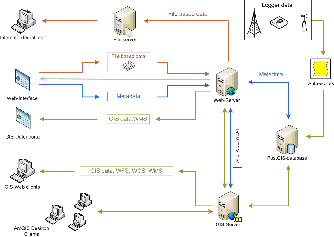
On the basis of the data management plan technical infrastructures will be implemented and set up in each centre:

Outline oft the data management infrastructure being established at FZJOutline oft the data management infrastructure being established at FZJ


Members

  • Ralf Kunkel (FZJ)
  • Robert Eckardt (UFZ)
  • Rainer Gasche (KIT)
  • Mark Frenzel (UFZ)
  • Olaf Kolditz (UFZ)
  • Frank Neidl (KIT)
  • Karsten Rink (UFZ)
  • Jürgen Sorg (FZJ)
  • Vivien Stender (GFZ)


Significantly declining lake levels are observed at several locations in northeastern Germany during the last decades and commonly are related to the ongoing climate change. In the public discussion often even catastrophic scenarios are evoked, pointing to a dangerous aridification of the region. However, the controlling mechanisms for lake level fluctuations and related processes are yet poorly understood. In addition to climatic influences, man has increasingly impacted on the regional hydrology since medieval times, most probably in response to both climate change and societal development. Reorganisations of the regional water budget include damming as well as large-scale drainage.